The 2005 MTF Poker Run From Hell
The Sniffin' Rides
River Roads
 |
The 2005 MTF Poker Run From Hell |
The Sniffin' Rides |

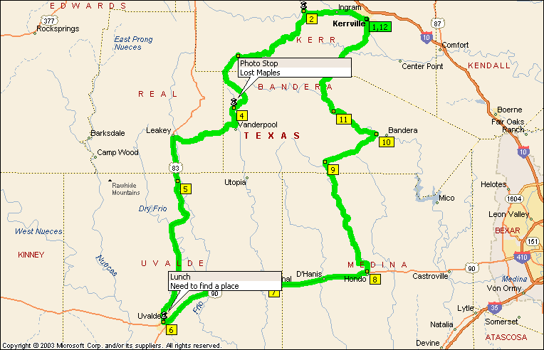
This is a collection of roads that closely follow some of the streams and rivers in the area. It does use a stretch of US90 to make it a little quicker to get back west but the alternative down to Yancey and Moore then back to Uvalde is not very interesting and adds a few miles. A lot of these roads are covered on other routes, but by putting these together, it creates a nice, easy ride. It also allows time for stops at places like Lost Maples Recreation Area and The Texas Stonehenge in Hunt. If you wanted a little longer day, and the place is open, a stop at the motorcycle museum just north of Vanderpool is worthwhile. Uvalde provides a convenient half way point for lunch.
Summary: 222.9 miles (6 hours, 56 minutes)
|
Time |
Mile |
Instruction |
For |
Toward |
|
8:00 AM |
0.0 |
Depart Kerrville on Local road(s) (South-West) |
76 yds |
|
|
8:00 AM |
0.1 |
Turn LEFT (South-East) onto McFarland Dr [McFarland St] |
43 yds |
|
|
8:00 AM |
0.1 |
Turn LEFT to stay on McFarland Dr [McFarland St] |
153 yds |
|
|
8:01 AM |
0.2 |
Turn RIGHT (South-West) onto Hays St |
0.2 mi |
|
|
8:02 AM |
0.4 |
Turn RIGHT (North-West) onto SR-27 [Main St] |
0.3 mi |
|
|
8:03 AM |
0.7 |
Bear LEFT (West) onto SR-27 [Junction Hwy] |
5.2 mi |
|
|
8:12 AM |
5.9 |
Keep STRAIGHT onto SR-27 [HWY-27 E] |
0.5 mi |
|
|
8:13 AM |
6.4 |
Bear LEFT (West) onto SR-27 [HWY-27 W], then immediately bear LEFT (West) onto SR-39 |
0.3 mi |
|
|
8:14 AM |
6.7 |
Keep STRAIGHT onto SR-39 [HWY-39] |
0.2 mi |
|
|
8:15 AM |
6.8 |
Keep STRAIGHT onto SR-39 |
5.8 mi |
|
|
8:25 AM |
12.6 |
Turn RIGHT (North-West) onto Ranch Road 1340 |
0.9 mi |
|
|
8:27 AM |
13.5 |
Arrive near Hunt |
||
|
8:57 AM |
13.5 |
Depart near Hunt on Ranch Road 1340 (South-East) |
0.9 mi |
|
|
8:59 AM |
14.3 |
Turn RIGHT (South-West) onto SR-39 |
10.0 mi |
|
|
9:16 AM |
24.3 |
Turn RIGHT to stay on SR-39 |
10.1 mi |
|
|
9:34 AM |
34.4 |
Turn LEFT (South) onto Ranch Road 187 |
43 yds |
|
|
9:34 AM |
34.4 |
At Ranch Road 187, stay on Ranch Road 187 (South) |
6.0 mi |
|
|
9:44 AM |
40.5 |
Turn LEFT to stay on Ranch Road 187 |
8.2 mi |
|
|
9:58 AM |
48.6 |
Arrive Ranch Road 187 |
||
|
10:28 AM |
48.6 |
Depart Ranch Road 187 on Ranch Road 187 (West) |
3.9 mi |
|
|
10:35 AM |
52.6 |
Turn RIGHT (West) onto FM-337 [Ranch Road 337] |
3.5 mi |
|
|
10:41 AM |
56.1 |
Turn RIGHT to stay on FM-337 [Ranch Road 337] |
10.7 mi |
|
|
11:00 AM |
66.7 |
Keep STRAIGHT onto FM-337 [6th St] |
0.5 mi |
|
|
11:01 AM |
67.2 |
Turn LEFT (South) onto US-83 [Market St] |
3.8 mi |
|
|
11:05 AM |
71.0 |
Turn RIGHT (South) onto US-83 |
4.7 mi |
|
|
11:11 AM |
75.7 |
At Ranch Road 1050, stay on US-83 (South) |
31.0 mi |
|
|
11:50 AM |
106.7 |
Turn RIGHT (West) onto W School Ln |
0.3 mi |
|
|
11:51 AM |
106.9 |
Turn LEFT (South) onto N Park St |
43 yds |
|
|
11:51 AM |
107.0 |
At Uvalde, stay on N Park St (South) |
0.3 mi |
|
|
11:52 AM |
107.2 |
Turn LEFT (East) onto US-90 [W Main St] |
22.1 mi |
|
|
12:20 PM |
129.4 |
Turn RIGHT (South) onto SR-127 [FM-187] |
65 yds |
|
|
12:20 PM |
129.4 |
At Sabinal, stay on SR-127 [FM-187] (North) |
54 yds |
|
|
12:21 PM |
129.4 |
Turn RIGHT (East) onto US-90 [Fisher Ave] |
19.9 mi |
|
|
12:45 PM |
149.4 |
Turn LEFT (North) onto Avenue O |
0.3 mi |
|
|
12:46 PM |
149.6 |
Turn RIGHT (East) onto 15th St |
109 yds |
|
|
12:46 PM |
149.7 |
At near Hondo, stay on 15th St (East) |
131 yds |
|
|
12:47 PM |
149.8 |
Turn LEFT (North) onto Avenue M [Ranch Road 462] |
164 yds |
|
|
12:47 PM |
149.8 |
Keep STRAIGHT onto Avenue M |
1.0 mi |
|
|
12:49 PM |
150.9 |
Road name changes to FM-462 N |
22.4 mi |
|
|
1:28 PM |
173.2 |
Road name changes to Ranch Road 462 |
2.5 mi |
|
|
1:32 PM |
175.7 |
At Ranch Road 462, turn RIGHT (East) onto Ranch Road 470 |
0.2 mi |
|
|
1:32 PM |
175.9 |
Bear RIGHT (East) onto Ranch Road 470 [Ranch Road 472] |
3.6 mi |
|
|
1:39 PM |
179.5 |
Keep STRAIGHT onto Ranch Road 470 |
8.0 mi |
|
|
1:53 PM |
187.5 |
Turn RIGHT (South-East) onto SR-16 |
65 yds |
|
|
1:53 PM |
187.5 |
At SR-16, stay on SR-16 (North-West) |
10.7 mi |
|
|
2:11 PM |
198.2 |
Turn LEFT (South) onto Local road(s) |
32 yds |
|
|
2:11 PM |
198.3 |
At Medina, return North on Local road(s) |
32 yds |
|
|
2:12 PM |
198.3 |
Turn LEFT (West) onto SR-16 |
9.4 mi |
|
|
2:28 PM |
207.7 |
Keep STRAIGHT onto SR-16 [Medina Hwy] |
13.4 mi |
|
|
2:51 PM |
221.1 |
Keep STRAIGHT onto SR-16 [Sidney Baker St S] |
1.1 mi |
|
|
2:53 PM |
222.1 |
Turn LEFT (North-West) onto Water St |
0.3 mi |
|
|
2:54 PM |
222.4 |
Turn RIGHT (North-East) onto Hays St |
0.3 mi |
|
|
2:56 PM |
222.7 |
Turn LEFT (North-West) onto McFarland Dr [McFarland St] |
153 yds |
|
|
2:56 PM |
222.8 |
Turn RIGHT to stay on McFarland Dr [McFarland St] |
43 yds |
|
|
2:56 PM |
222.8 |
Turn RIGHT (North-East) onto Local road(s) |
76 yds |
|
|
2:56 PM |
222.9 |
Arrive Kerrville |